UrbanTech Transit Startup Remix Raises $15 Million
The Summary
Remix is currently being used by over 4,000 planners in over 300 cities to enable planners to visualize tradeoffs when making urban planning decisions.
The startup is attempting to streamline decision-making for city planners, allowing planners to drag and drop changes like re-route bus routes or additional bike lanes. Planners then see in real time how that change will affect other streets and the flow of transportation as a whole.
For cities, better planning results in shorter commute times, safer streets, and lower greenhouse gas emissions.
Over the last decade, cities across the country have benefitted from the adoption of GTFS (Google Transit Feed Specification) feeds that allow transit agencies and startups to integrate data, but city planners previously relied on a clunky combination of Excel spreadsheets and spatial software to make urban planning decisions. This patchwork approach to planning slowed down the process of making changes to urban areas, at a time when consumer transit patterns have been rapidly changing.
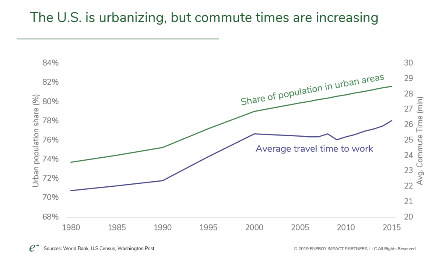
In addition to the need for more streamlined methods for planning, cities face significant challenges with regard to transit. These challenges include constantly increasing commute times, the urbanization of cities (which means more people commuting), the lack of public investment in big infrastructure projects that would ease the strain on existing infrastructure and lower commute times, the growing share emissions coming from vehicles moving around cities (compared to the share of emissions from buildings and industry, which have remained somewhat constant, the share of emissions from vehicles has grown), the introduction of new modes of transit into city streets (bike sharing, electric bikes, scooters), and issues related to how to repurpose parking to create more useable spaces and more housing.
In other words, Remix is helping to solve some major problems.
Parking as an Example of How Remix Can Impact Communities
“Parking is such a huge, huge point of contention for every city and being able to explain to somebody why a transit lane or a bike lane or a parklet might be more beneficial for the community at large as opposed to having people freak out over removal of two parking spots,” said Remix founder Tiffnay Chu. “That’s a shifting conversation we, as an industry, need to have in order for everyone to start moving in the right direction, away from single occupancy vehicles.”
With Remix, planners can visualize the impact of removing parking spots using data from multiple providers at the same time. This enables them to see things like usage patterns, the impact removing parking from different areas, the historical trends of a location, how the removal of parking spots changes the usage of an area over time, and real-time data as plans are implemented.
Smart city initiatives and open data projects have enabled Remix to get better over time. The startup initially started out using GTFS feeds, then moved on to using NACTO’s open data standard and the Mobility Data Specification (from the city of Los Angeles).
In an earlier blog post, founder Tiffany Chu listed other successful cities with projects that Remix has enabled:
Eugene, Oregon is reshaping their downtown street grid, expanding their network of protected bicycle lanes, and just launched a new bikeshare (both docked and dockless).
Montgomery County, Maryland. Outside of DC, MoCo encompasses rural, suburban, and highly urbanized neighborhoods, and is using Remix for several of their 30 Bicycle and Pedestrian Priority Areas.
Miami-Dade County, Florida. Named one of the most dangerous metros for pedestrians, Miami-Dade is turning that title around: they adopted a Complete Streets Resolution last year, embraced electric bikeshare, and are designing projects in Remix for their expedited Quick-Build Program.
The Remix Platform


